
trip

Mt Naya Kanga Peak Climbing with Langtang Trek
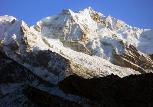
Langtang region is a popular destination for climbing snow peaks and spectacular panoramic views of mountains in Nepal and Tibet. Easy access to the region and availability of several snow peaks scattered around for acclimatization make this region an ideal destination for novice as well as experienced climbers. Naya Kanga is an attractive peak rising to the west of the Ganja La (5,122m). Ascending to Ganja La or the summit of Naya Kanga offer the spectacular panoramic views of mountains in Nepal and Tibet including Langshisa Ri (6,370m), Pemthang Ri (6,836m), Shisapangma (8,046m), Langtang Lirung (7,425m), Pemthang Kapro Ri (6,830m) and Langtang II (6,571m). The normal route of ascent to Naya Kanga is via the north – East Ridge over a line on ice and snow. We follow the route of Langtang trek to Kyangjin (3,749m) for the ascent of Naya Kanga.

Mt Yala Peak Climbing with Langtang Trek
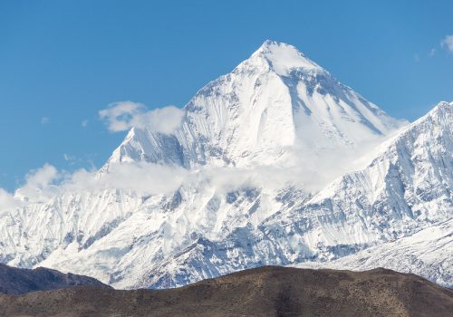
Mt Yala Peak Climbing, a beautiful trekking experience that leads all the way to the summit of Yala Peak (5550 m), is an easy mountaineering experience within a short period of time, in the Langtang Region of Nepal. You will be rewarded by the spectacular views of Mountains dominated by the Lantang Lirung, Dorje Lakapa and Shisapagma. Due to its average height, it has attracted many climbers in the recent period. The climb doesn’t require any technical skills but is physically challenging. The use of fixed rope and crampons become handy in the steep ice section of the final climb. Apart from conquering the Himalayan summit, the trekking is itself an exciting adventure. You will closely experience the Himalayan lifestyles and Tibetan culture in its pristine form. You will also be amazed by the turquoise Lakes, massive glaciers and high passes on the way.
Experience the amazing Yala peak climbing in Nepal
The walk starts from Syafrubesi within the lush forests trail moving along the river flowing through a narrow Gorge, taking us all the way to Langtang Valley. The valley lies in the lap of high snow capped giants in the north and small peaks in the south. The place devastated by the Earthquake in April 12, 2015 has never lost its natural grace. Moving a little higher, we reach Kyanjing Gompa (3740m), place named after an ancient monastery. We can visit monasteries and cheese factory in the nearby’s. From there we head to Yala Peak Base camp and conquer the Yala Peak. After achieving our quest, we ascend down through the same route.
Global Holidays Adventure boasts of the high quality service and wisely designed packaged trip to Yala Peak climbing. We have been operating successful Yala Peak Climbing since a decade back. What make us different are the hassle free quality service we offer to our clients, the wisely designed itineraries providing enough acclimatization days ensuring the proper health condition of the climbers and, above all, our highly successful and experienced Sherpa Guides, who have the guts and wits to face and tackle the various contingencies that may arise in the Himalayan region. Our Sherpa guides will provide you the necessary mountaineering training on the use of ropes and crampons. You don’t need any of the previous mountaineering experience but physically fit health condition is the prerequisite of this climb. Your safety is the prime concern of Global Holidays Adventure.
Other famous peak climbing for the climb-freaks are Island Peak Climbing, Mera Peak Climbing, Lobuche Peak Climbing, and find more here Nepal Peak Climbing.
Mt. Kanchanjunga Expedition (8586M)
Mt. Kanchanjunga, at 8598m, is the third-highest peak in the world and the second-highest in Nepal. It was first climbed by a British team in 1956. The peak consists of four summits. The west summit, Yalung Kang, is 8420m high and some people classify it as a separate 8000m. peak. Thee first Westerner to explore Kanchanjunga was the British botanist JD Hooker, who visited the area twice in 1848 and 1849. Exploration of the Sikkim, side of the peak continued with both British and pundit explorers mapping and photographing until 1899. In that year a party led by Douglas fresh field made a circuit of Kanchanjunga and produced what is still one of the most authoritative maps of the region. Exploration continued, mostly from the Sikkim side, with expeditions starting from Darjeeling in British India.
One of the major contributors to Western knowledge about the region was Dr AM Kellas, who later died in Tibet during the approach march of the 1921 Everest expedition. German expeditions attacked the peak in 1929, 1930 and again in 1931, but none was successful. After the was Sikkim was closed but Nepal was open. In 1955 a team led by Dr Charl es Evans approached the peak via the Yalung Glacier. Two teams climbed the peak, stopping just short of the summit to conform to an agreement with the Maharaja of Sikkim that the summit would remain inviolate. The Japanese then took up the challenge and mounted expeditions in 1967, 1973 and n1974. when they climbed Yalung Kang. A German Expedition climbed Yalung Kang in 1975, and in Indian army team mounted the second successful expeditions to the main peak of Kanchanjunga.


Mt. Makalu Expediton (8485M)
You can also climb Mt Mera Peak just before the Makalu climbing for the training and acclimatization.

Mt. Manaslu Expedition(8163M)
Mt. Manaslu (8156m) was first climbed in 1956 by a Japanese expedition. Its name comes from the Sanskrit word manasa, meaning “intellect” or ” soul” It is the same root word as that for Manasarover, the holy lake near Mt. Kailash in Tibet. Just as the British considered Everest their mountain. Manaslu has always been a Japanese mountain. HW Tillman and Jimmy Roberts photographed Manaslu during a trek in 1950. but the first real survey of the peak was made by a Japanese expedition in 1952.
A Japanese team made the first serious attempt on the peak from the Budhi Gandaki valley in 1953. When another team followed in 1954, the villagers of Samagaon told them the first team had been responsible for an avalanche that destroyed a monastery. and refused to let the 1954 expedition climb. The expedition set off to climb Ganesh Himal instead. Despite a large donation for the rebuilding of the monastery, subsequent Japanese expeditions, including the one that made the first ascent in 1956, took place in an atmosphere of animosity and mistrust. The second successful Japanese expedition was in 1971. There was a South Korean attempt in 1971, and in April 1972 an avalanche that killed five climbers and 10 Sherpas ended the second made the fourth ascent of Manaslu as a member of a Tyrolean expedition that climbed from the Marshyangdi valley in 1972.

Mt. Everest Expedition (8848M.) – South
Himalayan Windhorse Adventure has more than two decades experiences for organizing and handling the high mountaineering climbing expeditions. All our crews are native and professional to make your dream come true. We await to serve our quality and luxury services.

Makalu Base Camp Trek
The spectacular trek to Makalu Base Camp has long been one of Nepal’s best kept trekking secrets. Closed to the outside world until the 1950s, when Eric Shipton first trekked into the region, it has remained relatively inaccessible and little-known except to a handful of keen trekkers; camping en route. We are delighted to now be able to offer the trail to the foot of the world’s fifth highest peak as a tea house trek, and although accommodation is simpler than in more established trekking areas, the tea houses offer a welcome place to stay along the way.
The trail to the foot of the world’s fifth highest peak, takes you through the pristine wilderness of Makalu Barun National Park, recognised for its outstanding natural beauty and great diversity of flora and fauna. It also has great variety and contrast of scenery with every day bringing a rich selection of scenic rewards as you climb from 700m to over 5,000m.
The trekking is challenging but immensely rewarding. On a single day alone you cross four high passes, including the Shipton La (Eric Shipton’s original expedition route) three of which are over 4,000m – a truly stunning day’s trekking. And, if you do this trek in the spring when there may be lingering snow, crossing the passes is even more exciting. The final approach to Base Camp is undoubtedly one of the best and most scenically spectacular walk-ins anywhere in the world and, when you finally reach Base Camp, Mount Makalu utterly dominates with its majestic, monumental presence. It makes you realise how daunting it would be to climb this 8,416m beast. From a viewpoint above the base camp, you can enjoy an epic panorama of some of the Himalaya’s highest peaks including Everest, 8,848m, Lhotse, 8,516m, Chamlang, 7,319m, and Baruntse, 7,129m.
Although this is an out and back trek, the vistas are superb in both directions, and you have the key advantage that if your views were obscured by cloud on your way out, you have a second chance to see them on your return. In fact, this trek has all the ingredients to make a truly memorable and thrilling journey; high passes, soaring 8,000m peaks, incredible scenery, a rewarding objective and splendid isolation.
Rolwaling / Khumbu Trek
Welcome to Nepal!
We begin our journey with a scenic drive on the Kathmandu – Lasha highway to the ancient trading town of Dolakha.
Our walking through a scheduled and one of the most beautiful parts of Nepal starts here. We trek through the Rolwaling valley, celebrated as one of the seven hidden valleys in the Himalayan, past beautiful Sherpa and Tamang villages. Rolwaling is the East -West valley below Gauri Shanker (7145m) just south of Tibetan border. Beding and Na is the last Sherpa village of this valley, where more than 20 good Sherpa climbers, have conquered Mt. Everest and numerous other 8000m peaks. We cross over the Tashi Lapcha pass (5755m) and visit Thame, Tenzin Norgay’s hometown, and enter the Khumbu valley, the land of the Sherpas which lies at the foot of Everest. Great views of Mt. Gauri shanker, Mt. Dorje Lakpa and Mt. Tashi Lapcha all along the trail. This trek also offers a great opportunity for short climbs of peaks like Ramdong Go (5930m) and Pharchamoro (6187m). This trek being strenuous, technical climbing experience and good mountaineering gear are essential.

Larkela Pass Trek
Larke La Pass Trekking is a rare opportunity to explore a relatively new trekking region in Nepal. Abundant in spectacular views along the border of Nepal and China, Larke La Pass located in the west of Kathmandu in the Manaslu Region, situated at the elevation of 5135m (16844ft). This trek officially opened to tourists in 1991. Mountaineering expeditions have long had access to the area, though.
This trek starts from Arughat of Gorkha District and ends in Beshishahar of Lamjung District in the Annapurna Region. The complete circuit of Manaslu over the Larke Pass (Larkya La Pass) is getting more and more popular as a new trekking destination, particularly after the Annapurna circuit trail started the motor road construction. The course is rough and passes through high trails above the river. With the admixture of vast geography, exotic Tibetan culture, and wilderness in the region, Larke La (5135m/16844ft.) is undoubtedly an ineffable pass crossing the Himalayan region in Nepal. During the trekking, the significant attractions Tibetan Sylla and Sama village, Amazing views of Manaslu and Ganesh Himal, Panoramic views of 10 peaks over 6000m, and the Larke La Pass itself.
Himalayan Windhorse always provide a high-quality service package to our clients. We provide hygienic and delicious food during the trek. More importantly, we serve you through some highly experienced Government-licensed trekking guides strong and experienced porters.
The trekking trail is moderate, so we have to arrange some trekking equipment like rope, Crampons, Trekking sticks, Trekking Boots, Down Jackets, etc. (gear list will be provided).